
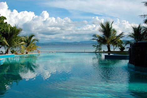
Komodo Island is an island located in the Nusa Tenggara islands. Komodo Island is known as a habitat for native animals dragons. The island is also the Komodo National Park is managed by the Central
Komodo
National Park includes three major islands: Komodo, Rinca and Padar, as well as
numerous smaller islands creating a total surface area (marine and land) of
1817km (proposed extensions would bring the total surface area up to 2,321km2). As well as being home to the Komodo dragon, the
Park provides refuge for many other notable terrestrial species such as
the orange-footed scrub fowl, an endemic rat, and the Timor deer. Moreover, the
Park includes one of the richest marine dnvironments including coral reefs,
mangroves, seagrass beds, seamounts, and semi-enclosed bays. These habitats
harbor more than 1,000 species of fish, some 260 species of reef-building
coral, and 70 species of sponges. Dugong, sharks, manta rays, at least 14
species of whales, dolphins, and sea turtles also make Komodo National Park
their home.

Komodo
National Park is located in the center of the Indonesian archipelago, between
the islands of Sumbawa and Flores. Established in 1980, initially the main
purpose of the Park was to conserve the unique Komodo dragon (Varanus
komodoensis) and its habitat. However, over the years, the goals for the
Park have expanded to protecting its entire biodiversity, both terrestrial and
marine. In 1986, the Park was declared a World Heritage Site and a Manand Biosphere Reserve by UNESCO, both indications of the Park's biological
importance.
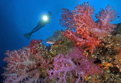
The
variety of marine life that you can see when you're Komodo scuba diving rivals
the world's best dive destinations. This is close to the world's epicentre for
marine diversity and you'll see loads of stuff here on a liveaboard diving
cruise that you just won't see anywhere else in the world.
From
sunfish,
mantas,
dolphins and
eagle rays to pygmy
seahorses, ornate ghost
pipefish, clown frogfish,
nudibranchs and blue-ringed octopus, all are at home amongst a spectacular
range of colourful sponges, sea squirts, tunicates and corals; Komodo is a macro enthusiast's heaven.

Geologically,
Komodo Island and Rinca are part of Flores, separated from Sumbawa to the west
by the Sape Strait. In the middle of the strait, the bottom drops to almost 300
metres. The many islands and relatively shallow seas between Flores and
Komodo's west coast mean very fast currents at tidal changes, especially when
the higher tidal waters of the Pacific Ocean in the north flow through into the
Indian Ocean to the south. The upwellings from the deep surrounding seas bring
nutrients and plankton to keep these waters rich and well-fed, which makes
perfect conditions for some spectacular scuba diving.

Threats to
terrestrial biodiversity include the increasing pressure on forest cover and
water resources as the local human population has increased 800% over the past
60 years. In addition, the Timor deer population, the preferred prey source for
the endangered Komodo dragon, is still being poached. Destructive fishing
practices such as dynamite-, cyanide, and compressor fishing severely threaten
the Park's marine resources by destroying both the habitat (coral reefs) and
the resource itself (fish and invertebrate stocks). The present situation in
the Park is characterized by reduced but continuing destructive fishing
practices primarily by immigrant fishers, and high pressure on demersal stocks
like lobsters, shellfish, groupers and napoleon wrasse. Pollution inputs,
ranging from raw sewage to chemicals, are increasing and may pose a major
threat in the future.
The
island is also famous for its Komodo dragon
monitor lizard, the largest lizard in the world. An alert and agile predator
and scavenger that can reach 2.5 metres in length and 125 kg, they are known
locally as 'Ora' and now about 1,100 inhabit the island and about half that
live on nearby Rinca Island.
Highlights
There
are a lot of excellent dive sites around the park, many of which would be the
jewel in the crown of lesser dive destinations but if we have to limit the
highlights then we could do no better than to recommend to you:
Cannibal Rock - Unlike many Komodo diving
sites, there is little heart-stopping action here but in terms of colour and
activity there are few better spots. There is just so much going on around this
sea mount: purple gorgonians, anemones, yellow and white spiral corals and sea
apples that together create a riot of colour. In and around this vibrant
sessile tableau live all sorts of sea-life making night diving here simply
awesome. All the while rays, snappers, sweetlips and turtles cruise around the
rock. Night or day, Cannibal Rock inspires.
Yellow Wall Of Texas - Another of Komodo
National Park's signature dives, Yellow Wall is so called because of the
proliferation of robust sea cucumbers - they are all over the place and their
bright yellow hue dominates the vista. Not only does the wall itself promise
much in the way of entertainment but sharks, manta rays
and turtles are all frequent passers-by.
Although there are a few resorts beginning to
pop up around the area, the dive sites are well spaced out and the only way to
truly see all of Komodo Island and the surrounding area is by liveaboard. There
are plenty of liveaboards and you should find something for
every budget
Reef
Summary
Good for: Large animals, small
animals, wall dives, underwater photography, drift diving, reef life and health
and advanced divers
Not so good for: Wrecks and beginner divers
Depth: 5 - >40m
Visibility: 5 - 30m
Currents: Can be very strong
Surface conditions: Can be rough
Water temperature: 20 - 28°C
Experience level: Intermediate - advanced
Number of dive sites: >35
Distance: ~490 km east of Bali (24 hours), 20 km west of Labuan Bajo (Flores, 2 hours), 90 km east southeast of Bima (Sumbawa, 8 hours)
Access: Komodo liveaboard cruises
Recommended length of stay: 6 - 11 days

Diving Season
You can go liveaboard diving in Komodo all year round. The
liveaboards here do not close for an off-season because every month of the year
promises top quality action. Overall, the absolute best visibility is from
November to January.
January to March can have rough surface conditions at the
northern Komodo dive sites. July and August can have rough seas in the south
and Rinca. But these conditions rarely interfere with the liveaboard schedules
to any great extent.
Government. Komodo Island is located east of the island of Sumbawa, separated by Sape Strait.
In 2009, the Park has been named a finalist "New Seven Wonders of Nature" newly published in 2010 by voting online at www.N7W.com
2. Bunaken Island

Bunaken is an island covering an area of 8.08 km ² at Manado Bay, situated on the northern island of Sulawesi, Indonesia.
Bunaken marine park has a 20 point dive (dive spot) with varying depths of up to 1344 meters. Of the 20 point dive, dive 12 points of which are located around Bunaken Island. Twelve-point diving is the most frequently visited by divers and lovers of the beauty of the underwater scenery.
Most of the 12 point dive in Bunaken island lined up from the southeast to the northwest of the island. In this region there is a great underwater walls, also called the hanging walls, or walls of a giant rock that stands vertical and curved upward. These rock walls are also a source of food for fish in the waters around Bunaken Island.
The Bunaken National Park is a marine park in the north of Sulawesi island, Indonesia. The park is located near the centre of the Coral Triangle, providing habitat to 390 species of coral as well as many fish, mollusc, reptile and marine mammal species. The Park is representative of Indonesian tropical water ecosystems, consisting of seagrass plain, coral reef, and coastal ecosystems.
It was established as a national park in 1991 and is among the first of Indonesia's growing system of marine parks. It covers a total area of 890.65 km², 97% of which is marine habitat. The remaining 3% of the park is terrestrial, including the five islands of Bunaken, Manado Tua, Mantehage, Nain and Siladen. The southern part of the Park covers part of the Tanjung Kelapa coast

A very rich coral ecosystem covers most of Bunaken National Park, dominated by fringing reef and barrier reef corals. There are about 390 species of coral recorded in the waters of the Park. A distinct feature is a 25-50 metre vertical coral wall which is inhabited by 13 coral genus. The seaweeds that can be found here include Caulerpa, Halimeda, and Padina species, while the dominant seagrasses, in particular in the islands of Montehage and Nain, are Thalassia hemprichii, Enhallus acoroides, and Thalassodendron ciliatum. The park is also abundant in different species of fish, marine mammals and reptiles, birds, molluscs and mangrove species.

About 90 species of fish live in the waters of the park, among them being the Emperor Angelfish, Almaco Jack, Spotted Seahorse, Bluestripe Snapper, Pinkish Basslet and Two-lined monocle bream. The species of mollusc include the Giant Clam, Horned Helmet Shells, Chambered Nautilus, and ascidians.
It is claimed that this park has seven times more genera of coral than Hawaii, and more than 70% of all the known fish species of the Indo-Western Pacific.

On land, the islands are rich in species of palm, sago, woka, silar and coconut. Among the animal species that live on the land and the beaches are Celebes Crested Macaque, Timor Deer, and Sulawesi Bear Cuscus. The mangrove forest of the Park contains, among others Rhizophora and Sonneratiaspecies. This forest is also rich in species of crab, lobster, mollusc, and sea birds such as gulls, herons, sea doves, and storks.
3. Wakatobi Island

Wakatobi National Park is a marine national park, south of Sulawesi island of Indonesia. The name of Wakatobi is an acronym of the four main Tukangbesi Islands: Wangi-wangi, Kaledupa, Tomia, and Binongko.
Location and topography
Wakatobi National Park is located south-east of Sulawesi, between 05°12’-06°10’S and 123°20’-124°39’E, between the Banda Sea to the north-east and the Flores Sea to the south-west.
It consists of four larger islands: Wangi-Wangi, Kaledupa, Tomia and Binongko, as well as many small islands such as Tokobao, North Lintea, South Lintea, Kampenaune, Hoga and Tolandono. The highest elevation is 274 metres (899 ft) on Wangi-Wangi, followed by Lagole Hill (271m) on Tomia, Terpadu Hill (222 m) on Binongko and Mount Sampuagiwolo (203 m) on Kadelupa.The water depth varies, with the deepest parts reaching 1,044 metres (3,425 ft).

Coral Reefs
In the park, there are panoramic beauty of the underwater world that has 25 fruit clusters of coral reefs. Group of coral reefs can be found about 112 species from 13 families, located at 25 points along the 600 km coastline. Coral species are: - Acropora formosa, - Hyacinthus, - Psammocora profundasafla, - Pavona cactus, - Leptoseris yabei, - molucensis Fungia, - Lobophyllia robusta, - Merulina ampliata, - Platygyra versifora, - glabrescens Euphyllia, - frondes Tubastraea, - Stylophora pistillata , - throchelliophorum Sarcophyton, and - Sinularia spp.
Is one of Wakatobi regency in Southeast Sulawesi, Indonesia.
The capital of this district is located at Wangi-Wangi, formed under the laws of the Republic of Indonesia Number 29 of 2003, dated December 18, 2003.
Wakatobi is also the name of the national park established in 1996, with a total area of 1.39 million hectares, involving marine biodiversity, scale and condition of coral occupies one of the highest priority of marine conservation in Indonesia.
Flora and Fauna
The types of vegetation found in the national park are mangrove forest, coastal forest, lowland swamp forest, riverbank vegetation, lowland rainforest, mountain rainforest and coral reefs. The Wakatobi Archipelago has 25 groups of coral reefs including fringing reefs, barrier reefs and atolls.

A survey conducted in 2003 identified 396 species of coral belonging to 68 genera and 15 families. These include Acropora formosa, Acropora hyacinthus, Psammocora profundasafla, Pavona cactus, Leptoseris yabei, Fungia molucensis, Lobophyllia robusta, Merulina ampliata, Platygyra versifora, Euphyllia glabrescens, Tubastraea frondes, Stylophora pistillata, Sarcophyton throchelliophorum, and Sinularia species.
Among the recorded species of seabird are the Brown Booby, Common Kingfisher and Malaysian Plover.
Turtles in the park include the Hawksbill turtle, Loggerhead sea turtle, and Olive Ridley.
4. Tulamben, BALI

Tulamben has been very popular among domestic and foreign divers. What makes Tulamben so famous? None other than the ease and richness of marine life at this dive site. Coupled with the USS Liberty shipwreck that is easily accessible and serves a variety of underwater creatures ranging from tiny sea creatures such as snails, crabs and shrimp, ghost pipefish and pygmy seahorse to such large sharks, Mola mola, and others. Tulamben offers dive sites suitable for diving courses, dive leisurely (fun dive) and underwater photography.
Tulamben is located at northeast coastal of Bali, is one of the few stretches on Bali where village life is largely unaffected by tourism. Breathtaking slopes of tiered ricefields alternate with massive black rivers of volcanic rubble, the ravages of Agung Mount's 1963 eruption. There is a coral outcropping about 100 meters away to the east from Tulamben. There are some good diving sites inTulamben area.

Located on the north eastcoast of Bali, there is a small town, yet very popular as one of the top ten
best diving sites in Bali, named Tulamben. For its fortunate location,
Tulamben receives major ocean current from Pacific to the Indian ocean (or vice
versa) of plankton rich water. This makes Tulamben bay has an incredible
underwater ecosystem diversification. It is a wonderful place to learn to
dive and studied underwater life.
Here are the highlights of Tulamben Bay:
• The Liberty Wreck. The Liberty is the US army cargo ship. It was motoring across the Lombok strait from Australia to Philippines when it was torpedoed by Japanese submarine. Before it was sinking, the Liberty was towed to Singaraja, northern coast of Bali. Unfortunately, the ship was leaking badly, there was too much water inside the Liberty. She didn’t make it to Singaraja, and instead being sat grounded in the shallow part of Tulamben Bay for more than 20 years. In 1963, because of the subsequent earthquakes of Mount Agung eruption, the Liberty rolled out into deeper water and broke its bow and stern. It sat still right there until now. The wreck can be accessed directly from the shoreline, as it is only about 25 meters from the shore. The wreck’s deepest point is around 30 meters from the surface and it tops out at about 5 meters from the surface. The wreck middle’s depth is around 16 – 20 meters. It is such an easy wreck dive that can be done by all levels of divers. • The Drop – Off. Actually it is a spur of volcanic rock (an old lava flow from Mount Agung) that leads out from the rise on which the temple sits. The dropp – off is located at the opposite end of the bay from the wreck. We can start the dive at 10 meters with a steep sandy slope where there are big sponges with many varieties of shrimp and lionfish. Not to stop here, turn to the right and there is a very impressive topography, a vertical wall from 15 meters and descending to below 60 meters. At 28 meters depth, there is the crown jewel of the drop – off, a sea fan (around 2 meters across), inhabited by the lovely pigmy seahorses. If the weather is great, the visibility here can reach 20 meters, usually in the morning with low tide. There is almost no current, or at least a mild current only. Divers might encounter the white tip reef shark, napoleon, bump head, parrot fish, moray eel and octopus, or even wide variety of lionfish in the afternoon.
• The Liberty Wreck. The Liberty is the US army cargo ship. It was motoring across the Lombok strait from Australia to Philippines when it was torpedoed by Japanese submarine. Before it was sinking, the Liberty was towed to Singaraja, northern coast of Bali. Unfortunately, the ship was leaking badly, there was too much water inside the Liberty. She didn’t make it to Singaraja, and instead being sat grounded in the shallow part of Tulamben Bay for more than 20 years. In 1963, because of the subsequent earthquakes of Mount Agung eruption, the Liberty rolled out into deeper water and broke its bow and stern. It sat still right there until now. The wreck can be accessed directly from the shoreline, as it is only about 25 meters from the shore. The wreck’s deepest point is around 30 meters from the surface and it tops out at about 5 meters from the surface. The wreck middle’s depth is around 16 – 20 meters. It is such an easy wreck dive that can be done by all levels of divers. • The Drop – Off. Actually it is a spur of volcanic rock (an old lava flow from Mount Agung) that leads out from the rise on which the temple sits. The dropp – off is located at the opposite end of the bay from the wreck. We can start the dive at 10 meters with a steep sandy slope where there are big sponges with many varieties of shrimp and lionfish. Not to stop here, turn to the right and there is a very impressive topography, a vertical wall from 15 meters and descending to below 60 meters. At 28 meters depth, there is the crown jewel of the drop – off, a sea fan (around 2 meters across), inhabited by the lovely pigmy seahorses. If the weather is great, the visibility here can reach 20 meters, usually in the morning with low tide. There is almost no current, or at least a mild current only. Divers might encounter the white tip reef shark, napoleon, bump head, parrot fish, moray eel and octopus, or even wide variety of lionfish in the afternoon.

• The
Coral Garden
It’s a 200 meters long delightfully rich patch reef in 5 – 12
meters under water , covered with croporid, hard coral and some fire coral,
interspersed with anemones and sponges. This site is not wide, but it
supports vary diverse fish population, like snapper, angelfish, wrasse, parrotfish,
black tip shark, and millions of common reef fish. Even sometimes divers
might see the rare ones, like blue ribbon eels (the juveniles are black)
frogfish and unusual scorpion fish ad ghost pipe fish.
In the depth deeper
than 12 meters, divers might see barrel sponges with many juvenile emperor, a
school of juvenile catfish, a school of razor fish and two spot lion
fish. Not to stop here, turn to the right toward the drop off, along the
slope, there is a dry river bed, a gray bowl of rock and sand with no structure
other than small sound ridges radiating out into deep. The coral garden
is such an outstanding, easy, relaxing and a popular site for night
diving.
• Batu Kelebit
This beautiful site can be reached
only 15 minutes by jukung (traditional Balinese boat) from Tulamben bay.
Batu Kelebit site has two large underwater boulders lying just off shore from a
point marked by a jagged crest of lava. The steep ridges here encrusted
with an incredible diversity of hard corals, sea fans, fire coral and
sponges. Amazingly, this site has bright white sand and different
habitants from those in Tulamben bay.
Many says that fishes and invertebrates
life here are richer than Tulamben bay. Divers might have more chance to
see big pelagic, such as dog tooth tuna, mantas, schools of barracuda and
always the reef white tip sharks. The visibility are excellent, since
Batu Kelebit receives deep off shore water, the temperature is a bit cold
though. The cuurrent tends to northwest and since the ridges here provide
excellent protection, so it is save here.
Reef Type : the ship wreck of the Liberty , wall Traveling Time : from Sanur 2 hours drive Visibility : up to 20 meters Current : rare current Coral : encrusting animals on wreck, fine coral wall Fish : superb numbers and variety Highlights : night diving at full moon Other : the area can be crowded in the middle of the day Please contact us for more information about Tulamben Diving or other Bali diving trips
Reef Type : the ship wreck of the Liberty , wall Traveling Time : from Sanur 2 hours drive Visibility : up to 20 meters Current : rare current Coral : encrusting animals on wreck, fine coral wall Fish : superb numbers and variety Highlights : night diving at full moon Other : the area can be crowded in the middle of the day Please contact us for more information about Tulamben Diving or other Bali diving trips
5. Raja Ampat Islands

Raja Ampat is one of the districts in the province of West Papua,Indonesia. Capital city is located in Waisai. This district has 610 islands. Four of them, namely Pulau Misool,Salawati, Batanta and Waigeo, the larger islands. Of the wholeisland is only 35 islands are inhabited while the islands are uninhabited and mostly do not have a name.
As the islands, the only inter-island transportation and supportingcommunity activities Raja Ampat is the ocean freight. Similarly toreach Waisai, the district capital. When using the aircraft, first to the city of Sorong. After that, the trip&nbrp;from Sorong to Waisaifollowed by sea transport. Facilities available are fast boats with a capacity of 10, 15 or 30 people. At a cost of about Rp. 2 million,Waisai can be reached within 1.5 to 2 hours.

Historically, in the Raja Ampat Islands, there are four traditionalkingdoms, each of which is the kingdom Waigeo, with his power base in Wewayai, Waigeo island; Salawati kingdom, the center of power in Samate, North Salawati island; kingdom Sailolof thecenter of power in Sailolof, island South Salawati, and thekingdom Misol, the center of power in Lilinta, island Misol
The islands are the most northern pieces of land in the Australian continent. The name of Raja Ampat comes from local mythology that tells about a woman who finds seven eggs. Four of the seven eggs hatch and become kings that occupy four of Raja Ampat biggest islands whilst the other three become a ghost, a woman, and a stone
The islands are the most northern pieces of land in the Australian continent. The name of Raja Ampat comes from local mythology that tells about a woman who finds seven eggs. Four of the seven eggs hatch and become kings that occupy four of Raja Ampat biggest islands whilst the other three become a ghost, a woman, and a stone

History shows that Raja Ampat was once a part of Tidore Kingdom, an influential kingdom from Maluku. Yet, after Holland invaded Maluku, it was shortly claimed as a part of the kingdom of Holland. The main occupation for people around this area is fishing since the area is dominated by the sea. They live in a small colony of tribes that spreads around the area. Although traditional culture still strongly exists, they are very welcoming to visitors. Their religion is dominantly Christian.

The oceanic natural resource around Raja Ampat makes it significantly potential as a touristic area. Many sources place Raja Ampat as one of their top ten popular places for diving whilst it becomes number one in terms of underwater biodiversity.
The Raja Ampat area of Northwest Irian Jaya is filled with
islands, surrounded by reefs and inundated with fish. The Raja Ampat
archipelago encompasses nearly ten million acres of land and sea off the
northwestern tip of Indonesia’s
West Papua Province. Raja Ampat means “Four Kings,” and consists of the four
large islands of Waigeo, Batanta, Salawati, and Misool, plus hundreds of
smaller islands. Raja Ampat is also located in the “Coral Triangle”, the heart
of the world’s coral reef biodiversity, therefore the seas around Raja Ampat
possibly hold the richest variety of species in the world.

According to Conservation International, marine surveys
suggest that the marine life diversity in the Raja Ampat area is the highest
recorded on Earth. Diversity is considerably greater than any other area
sampled in the Coral Triangle composed of Indonesia, Philippines and Papua New
Guinea. The Coral Triangle is the heart of the world’s coral reef biodiversity,
making Raja Ampat quite possibly the richest coral reef ecosystems in the
world.

The area’s massive coral colonies along with
relatively high sea surface temperatures, also suggest that its reefs may be
relatively resistant to threats like coral bleaching and coral disease, which
now jeopardize the survival of other coral ecosystems around the world. The
Raja Ampat islands are remote and relatively undisturbed by humans.
1,309 fish species, 537 coral species (a remarkable 96% of
all scleractinia recorded from Indonesia are likely to occur in these islands
and 75% of all species that exist in the world), and 699 mollusk species, the
variety of marine life is staggering. Some areas boast enormous schools
of fish and regular sightings of sharks, such as wobbegongs.
Although accessing the islands is not that
difficult, it takes some time. It takes six hours flight from Jakarta, the
capital city of Indonesia to Sorong. Then, taking boat to reach the islands is
necessary.
6. Lembeh Strait
Lembeh Strait is a
narrow waters (straits) that separates the mainland with the island of
Sulawesi, Lembeh Island. Bitung city is located on one side of the strait.
Strait is known to have a wealth of marine biodiversity is very high and became
one of the major dive attractions in North Sulawesi. Lembeh Strait or so-called
Lembeh Strait is a favorite tourist spot for fans of underwater tours. Variety
of flora and fauna such as coral reefs and colorful marine fauna are
breathtaking certainly invite admiration for everyone who sees it. For your
information, including the waters of Lembeh Strait in the District of South
Bitung, Municipal Bitung, North Sulawesi Province. Waters is famous for its
dazzling diversity of invertebrates, especially of the Echinodermata.


Although most divers come here for the muck diving, Lembeh has much more
to offer. Specially around Lembeh island there are some small but very beautiful
coral reefs and at the northern tip at Batu Kapal the currents attract large
pelagics like mackerels and sharks. There are also four beautifully covered
wrecks, two of them large and all within limits for recreational diving. This
area is not a national marine park unfortunately. Water temperatures can
sometimes be a bit cold, in July-August it can be until 26 °C, the other months
around 28 °C. The sheltered condition of Lembeh Strait makes for year-around
diving.
The main town, Bitung can be reached by car (1 - 1 1/2 hour depending on traffic) from Manado. Bitung is a large, busy harbor full of containerships and fishing boats. In the last few years the town has prospered. In 2007 it was even awarded a price for being one of Indonesia's cleanest and healthest city. Situated on the eastern side of the tip of North-Sulawesi, the Lembeh strait (Selat Lembeh) runs between the Sulawesi mainland and Lembeh island to the east and is 22 km long and 2 km wide. There are some interesting white limestone walls and a few smaller islands or rocks (Batu Sandar, Sarena Kecil, Kai-nah) in the middle of the strait and a lava flow visible around Batu Angus (= burnt rock). Lembeh island is also an interesting place with some wildernes areas where Tarsias monkeys, large monitor lizards, birds and land turtles live.
7. Bangka Island The main town, Bitung can be reached by car (1 - 1 1/2 hour depending on traffic) from Manado. Bitung is a large, busy harbor full of containerships and fishing boats. In the last few years the town has prospered. In 2007 it was even awarded a price for being one of Indonesia's cleanest and healthest city. Situated on the eastern side of the tip of North-Sulawesi, the Lembeh strait (Selat Lembeh) runs between the Sulawesi mainland and Lembeh island to the east and is 22 km long and 2 km wide. There are some interesting white limestone walls and a few smaller islands or rocks (Batu Sandar, Sarena Kecil, Kai-nah) in the middle of the strait and a lava flow visible around Batu Angus (= burnt rock). Lembeh island is also an interesting place with some wildernes areas where Tarsias monkeys, large monitor lizards, birds and land turtles live.

BangkaBelitung Island is a province with archipelago nomenclature. Consisting of
approximately 81,725,14 km sq. land with its 16,424,14 km sq and wide
territorial water is 65,301 km sq, 20% among others represent territorial water
of rock. Consisting of 2 big islands, Bangka Island and also 254 islets
surrounding them with coastal length is 1,200 km sq, divided in 7
sub-provinces.


Entry
Get a flight from Soekarno-Hatta Airport. Or you can visit Bangka Belitung by boat from Palembang.
Get a flight from Soekarno-Hatta Airport. Or you can visit Bangka Belitung by boat from Palembang.

People & Culture
The Chinese make up at least 20% of the population of Babel. The majority of the Chinese are direct descendants of the coolies who worked the tin mines. The oldest temple is in Batu Rusa, a village along the road from Pangkalpinang to Sungai Liat. A beautifully decorated temple is found near Tayu in the north of Bangka Island. There are approximately 55 Chinese or Buddhist temples on Bangka alone that are still in use.
The Chinese make up at least 20% of the population of Babel. The majority of the Chinese are direct descendants of the coolies who worked the tin mines. The oldest temple is in Batu Rusa, a village along the road from Pangkalpinang to Sungai Liat. A beautifully decorated temple is found near Tayu in the north of Bangka Island. There are approximately 55 Chinese or Buddhist temples on Bangka alone that are still in use.
Cuisine
Due to its proximity to sea, sea food has become a favorite. Chinese influence also can be seen in the dishes that mainly use Chinese spices. While you're here try gebung, the local dialect for chicken fish. Its firm and tasty flesh will delight your senses.
8. Banda Island

Banda Islands are located on the southeastern island of Ambon, which consists of 10 small islands covering total area of 55 km2. The three largest islands in this region is the island of Neira, Pulau Besar and Banda Island Volcano.
Water areas in these islands have underwater life was amazing; underwater paradise for divers. Travelers can also do snorkeling in the coral reef is very beautiful. If that was not enough, is available to climb Mountain of fire.
Indonesia's
Banda Islands are historically famed for their spices, but they also possess
some excellent scuba diving around the coast line of this tiny five island
group.
We got four
dives in at the Banda Islands after arriving there from Nusa Laut and before
setting out the next day to head for the remote island of Manuk in the heart of
the Banda Sea. There is a profusion of dive sites around Banda so this was a
quick glimpse. Sorsongi and Banda Ai's Tenjung Udang (Shrimp Point) were a good
start to the day - the former a gentle slope with great viz and beautiful
corals, the latter a coral encrusted wall. They provided a fascinating contrast
to our third dive at the Lava Flow at the Banda island Gunung Api (not to be
confused with Gunung Api,
the island of the sea snakes, in the middle of the Banda Sea. Gunung
Api means "fire mountain" in Bahasa Indonesia, and as such there are
many volcanos across Indo with the same name).

Banda's
Gunung Api is still very much active, with the last eruption as recently as
1988. What's remarkable about this black, volcanic site where you can see the
tranches created by the lava flow - which is a pretty impressive monument in
itself to the power of nature - is just how fast the coral have grown back
here. You'd think that the lava would have wiped out all chance of life - but
there is a flourishing, vast carpet of staghorn coral, plate corals and table
corals now growing where the lava once flowed.
Bandanaira Jetty provided a
superb environment for a gentle night dive, with frogfish and a cluster of
juvenile sweetlips taking refuge amongst the jetty's pylons. Like Ambon, this
was another muck dive par excellence, and another great contrast to the day's
dives
9. Alor

Alor is an island located in the Nusa Tenggara islands east end. Its area is 2119 km ², and its highest point 1839 m. The island is limited by the Flores Sea and Banda Sea to the north, south Ombai Strait (separating the island of Timor), and Pantar Strait in the west (separated by Pantar island. Island of Alor is one of the 92 outer islands of Indonesia as directly adjacent to the Timor Leste in the south.
Many foreign tourists who had to Alor in awe. Because, besides the beautiful sea garden spoiled, they also discovered the phenomenon of sea parks are rare and very interesting. So, it's normal marine tourism with a panoramic view of Alor spefisik submarine in the Strait of Pantar be excellent and the teaser for the world-class diver from the United States, Australia, Austria, Britain, Belgium, Holland, Germany, Canada, New Zealand, and several countries in Asia.

lor is Indonesia 's newest Mecca for Muck diving
according to Larry Smith(R.I.P.), renowned expert on Indonesia 's most famous
Muck and strange critter diving locations.
"Alor is simply the best of the best".
Alor is teeming with numerous dive sites that
offer even the most seasoned of Muck divers an experience they will never
forget. So dust off those cameras and prepare to meet some weird creatures that
in any other context could come from another planet.
Dive Alor Dive have many
amazing sites that are literally crawling with some of the most unusual
critters that you can possibly encounter underwater, from Pegasus Sea Moths to
Mimic Octopus, Devil Fish to Ornate Sea Horses.
Orcas or Killer Whales are the largest of all the
Dolphins and swim in family groups of up to a dozen. Over the past decade, Dive
Alor Dive have documented the migrating habits of various groups of Orcas
through the Alor Archipelago.

On many previous occasions, they have offered
their guests the once in a lifetime opportunity to snorkeling with these
"Gentle Giants". The largest group they have encountered was a family
group of nine females with juveniles and one satellite male.
With this particular group,
they snorkeled with them on three separate occasions coming within meters of
them.

Diving or snorkeling with Sunfish is something
that eludes most divers, even the seasoned ones.In Alor, Sunfish have not only been seen by
Donovan, while diving, at most of his 40 odd dive sites but he's now discovered
the secret to snorkeling with them on a regular basis. Each individual animal has it's own markings,
much the same as a dairy cow, so they can be identify easily and you know if
you see the same one more than once. From around fifty separate
sightings over the years, Donovan has yet to encounter the same individual
twice. It can only be assumed from this that there are large numbers of Sunfish
inhabiting or migrating through the Alor Archipelago
10. Derawan Islands

The island is located in the Islands Derawan Derawan, District Derawan, Berau, East Kalimantan Island Unit Derawan morphology is bertopografi flat coastal plain. Sand beach has a slope of about 7 ° - 11 ° with a width of 13.5 to 20 meters.
In the surrounding waters are known as marine parks and diving (diving) with a depth of about five meters.

There are a wide variety of marine life here, such as squid (cuttlefish), lobster, fish pipe (ghostpipe fish), octopus (octopus bluering), nudibranchs, seahorses (seahorses), eel ribbon (ribbon eels) and fish Skorpion (scorpionfishes ).
On the rocks at a depth of ten meters, there are coral known as "Blue Trigger Wall" because of the reef with a length of 18 meters is a lot of trigger fish (red-toothed trigger fishes
Derawan
Island is an island with sea-colored blue and green shades are stunning, soft
sand, rows of coconut palms on the coast, with a small forest in the middle of
the island that’s become the habitat of various species of plants, animals and
natural beauty of the enchanting underwater. Make it as a dream island for
divers.
To explore
the island area you can use the shipor on foot. The Terrains at Derawan are
varied-from walls and fringing reef to caverns. Big green turtles , whitetip
leopard, napoleon wrasses, cuttle fish, spanish mackerel and batfishes, and
ornamental reef fishes.

No comments:
Post a Comment